Wildfire smoke billows into Seattle area with flurry of 911 calls
Updated 8 a.m., 9/8/2000: Smoke from huge wildfires east of the Cascades flowed into the Puget Sound region late Monday afternoon.
One fire complex alone had burned more than 300,000 acres as of Tuesday morning.
Labor Day fire storm destroys homes, burns thousands of acres across NW
The King County Sheriff's Office tweeted that its 911 center was being inundated by calls about the smoke and urged people to call only in an emergency.
But wildfires also erupted in the Puget Sound region.
Sponsored
Fires were reported near Bonney Lake, Sumner and Graham. Pierce County said evacuation orders were in place in areas nearest the fires. That included the El Dorado Estates neighborhood near Graham. Graham Fire and Rescue tweeted that a brush fire burned more than 100 acres overnight and destroyed several homes, but that it had the blaze under control early Tuesday.
Central Pierce Fire and Rescue urged people with respiratory illnesses to remain in doors.
On the Washington Smoke Information blog, readers were reporting smoke rolling across Snoqualmie Pass and into Puyallup and Maple Valley about 7 p.m. Monday.
Sponsored
An experimental forecast from NOAA showed near-surface smoke flowing over the mountains.
The Puget Sound Clean Air Agency's air monitoring system showed a spike in fine particulates in North Bend and nearby areas in the evening. The agency said air quality for sensitive groups was unhealthy in King, Snohomish, Pierce and Kitsap counties.
"We're expecting a large plume of smoke to drift over much of the Puget Sound later in the afternoon-overnight period" Tuesday, said Josh Clark, a fire meteorologist with the state Department of Natural Resources.
He said the small fires on the west side of the mountains would produce local smoke effects, and all of this could hang around through the rest of the week.
Sponsored
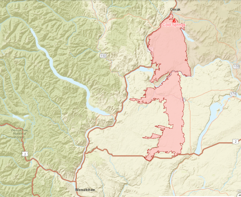
A big fire complex was burning in Eastern Washington south of Omak. The Cold Springs Canyon Fire / Pearl Hill Fire was burning along a north-south front that stretched more than 50 miles.
By Tuesday morning it had burned 314,000 acres, from the outskirts of Omak down to U.S. 2, according to mapping at the Northwest Interagency Coordination Center. That was a revision down from earlier numbers. (See the full map at https://gacc.nifc.gov/nwcc/information/firemap.aspx)
It forced authorities to issue Level 3 evacuation notices to the towns of Bridgeport and Mansfield. Highways in the area were closed, including US 97 between Brewster and Omak and US 2 in several spots.
Meanwhile, the Evans Canyon fire between Ellensburg and Yakima was about 70 percent contained after burning nearly 76,000 acres, according to numbers Tuesday morning from the Incident Information System.
And a fast-moving fire destroyed most of the homes and businesses in the small town of Malden, south of Spokane.
Sponsored
Sponsored
Related story: Pandemic ruins King County's planning for wildfire smoke
KUOW's Angela King and Kim Shepard contributed to this report.
-
Gil Aegerter

Gil edits feature pieces and helps guide staff reporters through their stories. He previously served as interim digital director and online managing editor at KUOW. Before that he spent seven years with NBCNews.com, where he was variously a senior editor, editor-producer and features editor. He also worked 25 years as a newspaper editor in Anchorage, Alaska, San Diego, Wilmington, N.C., and Seattle. He also was a freelance researcher for NBC Olympics for the Games in Atlanta; Sydney, Australia; Salt Lake City; Athens; and Torino, Italy. He is a graduate of the University of Alaska-Fairbanks, with a degree in photojournalism.
More stories from Gil Aegerter »


