Your Weather Forecast Update: Warmer Climate Will Be The New 'Normal'
It's become so common, perhaps you've stopped noticing how often your local weather forecast is "above normal." It's during extreme heat in the summer. It's when mild temperatures persist through the winter. It's when nights don't cool down like they used to.
But on May 4, the hotter Earth will officially become the new normal.
That's when the National Oceanic and Atmospheric Administration (NOAA) releases its once-a-decade update to "climate normals." They are the 30-year averages for temperature and precipitation that local meteorologists rely on as the baseline for their forecasts. To be sure, some updates will be miniscule. But the fastest-warming places will see a real bump in their averages that could make some forecasts seem confusing, and pose a challenge to meteorologists.
The current "normals" are from 1981-2010, based on data collected by thousands of monitoring stations around the country operated by the National Weather Service. The NOAA update will shift the time frame for those averages later, to the period from 1991 to 2020. The decade from 2011-2020 is one of the hottest on record in the U.S.
"It was a very substantial upward trend in temperature, especially along the West Coast, in the South and along the East Coast," says Mike Palecki, with NOAA's National Centers for Environmental Information.
Sponsored
There were exceptions; some places in the North Central part of the U.S. actually cooled a bit. But globally, the last decade ending in 2020 was the hottest decade ever recorded since 1880.
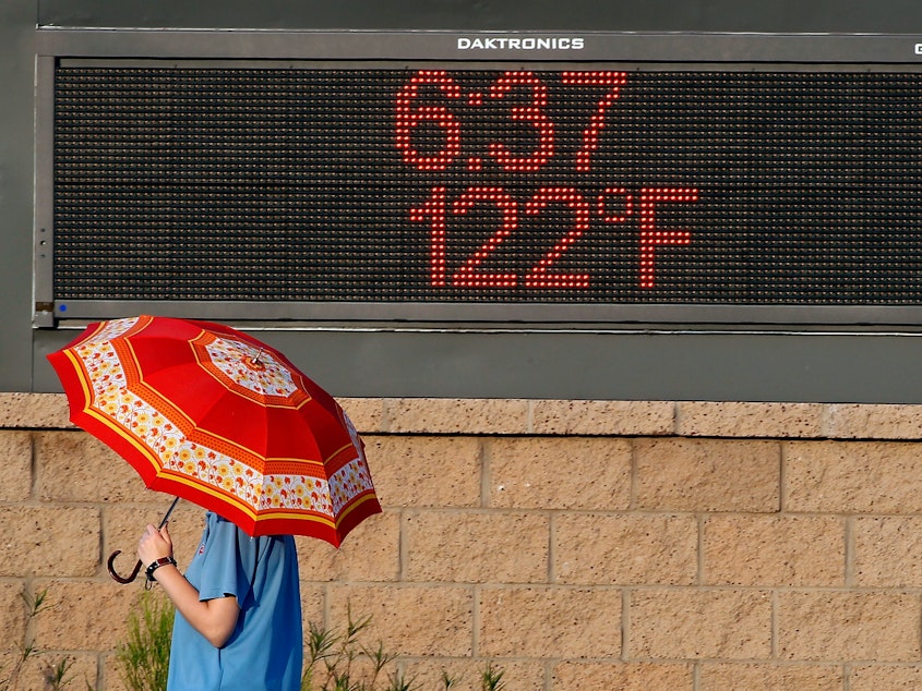
In Phoenix, Amber Sullins, chief meteorologist at ABC 15, has experienced rising heat in her hometown over her lifetime. Part of that is the urban heat island effect, as the city's expanding concrete terrain holds more heat overnight. But the latest National Climate Assessment finds greenhouse gases from human activity are making heat waves more common and drought more intense, with some of the highest temperature increases in the Southwest.
Sullins says last summer was especially brutal.
"We set a record of 53 days at 110 degrees or hotter. The previous record was 33 days, so it wasn't even close," she says. What's more, Sullins says that over the entire last decade, Phoenix did not set a single record for low temperature.
After the NOAA update in May, with the baseline for normal shifting to higher temperatures, forecasters in Phoenix and many other places might not be pointing out as many "above normal" days as before. In fact, some days considered warm now may become officially "cooler" when they get compared to the new temperature average. Sullins plans to take more time in her daily forecasts to explain the shift.
Sponsored
"We're going to have to remind people, especially this year, 'Hey, if we're at 115, that is 5 degrees above the average. But remember that this average has changed," she says.
A "slow grind" with big impacts
That context is important. Research shows that as unusual weather events happen more frequently, people simply reset their perception of what's normal. One study found a common reference point for "normal conditions" was only 2-8 years ago.
Frances Moore, a co-author of the study and professor of environmental policy at the University of California, Davis, has seen this speed of "normalization" in her own state. After 5 years of extreme smoke events from wildfires, she says people now simply say, "'Oh, fire season's coming, I guess we'd better get ready for it.'"
"We're not aware of how much warming is happening on a regular basis," says Bernadette Woods Placky, chief meteorologist with the non-profit Climate Central. "It's that slow grind that's eating away at the changing normal, that doesn't give you the opportunity sometimes to sit back and look at what it used to be."
Sponsored
Since the mid-20th century, the Earth has warmed about 2 degrees Fahrenheit, and the pace of that warming has picked up in recent decades. Scientists warn that humans must keep global temperatures from rising more than about 3 degrees Fahrenheit in order to avoid the most catastrophic effects of climate change.
But certainly, for many, the once-a-decade update to their local temperature averages is not likely to impress, if they even notice it at all.
"One degree warming doesn't sound like a lot to most people. In fact, people say, 'Oh great, I can have more cookouts in December more often,'" says Marshall Shepherd, director of atmospheric sciences at the University of Georgia.
And yet, the long term warming is so significant, he wonders if it's confusing to even use the term "normal" anymore.
Woods Placky works with local meteorologists to help them show this change. This year's update is an opportunity, she says, to explain what happened not just over the past 10 years, "but the 10 years previous to that, and 10 years previous to that, and look at how these changes are building up for the full picture."
Sponsored
Shepherd hopes meteorologists and other media also explain what the warming means for people's lives. For one thing, it's helped fuel the increasingly extreme wildfires, floods, and hurricanes that more people are enduring. He says there are also more subtle consequences to a hotter climate, like rising food prices, declining water supply, and the spread of vector-borne disease.
"It's about things happening right now that are affecting their kitchen table issues, their pocketbook, their livelihoods and their health," Shepherd says.
Many industries feel the brunt of the changing climate, too, and for them the official 30-year weather average is losing its relevance.
NOAA's Palecki says businesses want more recent data that reflects the risks they face now. Energy companies and utilities, for example, need an accurate sense of extreme heat and cold to calculate electricity demand and rate changes. The recent blackouts in Texas showed the high stakes around that. Weather predictions are also key to construction company contracts.
"They like to know how many days does it rain during a certain period of time, so they have a certain number of rain days that they build into their plans," says Palecki.
Sponsored
To help businesses better prepare, for the first time this year, NOAA will also put out 15-year averages, using more recent temperature and precipitation data. It's one of many ways the agency is helping people keep pace with a climate "normal" that just keeps changing. [Copyright 2021 NPR]


