Seattle records its warmest December. What does that mean for mountain snowpack?

Seattle just experienced its warmest December on record, and the trend is likely to continue through the rest of winter. That's bad news for Washington's mountains, which are currently quite low on snowpack.
"December temperatures across all of Washington state were between 3 and 6 degrees Fahrenheit above normal," Deputy State Climatologist Karin Bumbaco told Seattle Now. "So that's a pretty strong monthly anomaly."
The National Weather Service takes measurements for Seattle at Sea-Tac International Airport. December's daily average temperature for Seattle was 45.5 degrees Fahrenheit. That beats the old record (45.3 degrees) set in 2014.
Seattle was not alone. Olympia also hit 45.5 degrees in December, beating its previous high record (45 degrees) set in 1950.
Sponsored
Bumbaco wasn't entirely surprised by the warmth this season. Climatologists knew El Niño would influence the weather, causing a warmer, drier winter across the Northwest. The current forecast calls for more of the same through March with less precipitation and warmer temps.
RELATED: Ocean heat wave comes to Pacific Northwest shores
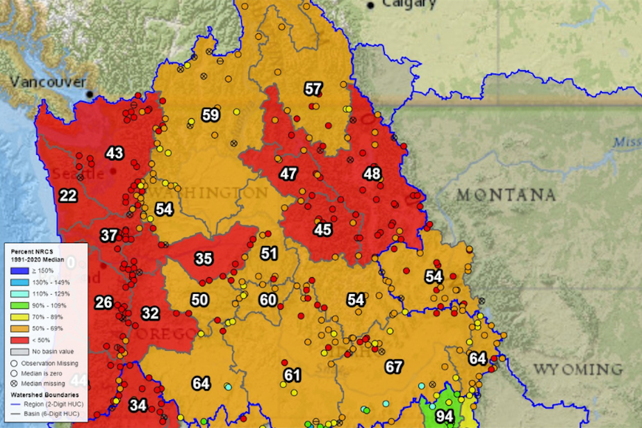
"The warm temperatures mean that the precipitation that we did see in December mostly fell as rain rather than snow in the mountains, so our snow is much below normal for this time of year average," Bumbaco said. "Statewide, it's only at 45% of median as of January 2, and several of the stations that monitor snowpack are at their record lowest for this time of year."
For example, Bumbaco said the Olympic Mountains are at their record lowest levels of snowpack. December and January are traditionally Washington's largest snow-delivering months.
"We would really have to see a lot of snow between January and March to get us to normal," Bumbaco said.
Sponsored
The snow is not just relied on for the ski season. Snowpack created in the winter creates the water that Washington relies on the rest of the year. Less snow in winter means less water for reservoirs downstream.
Regions across the Pacific Northwest are registering as either below 50% of normal snowpack, or between 50-69% of normal, as of Jan. 2, 2024, according to the U.S. Department of Agriculture.
"Our winters are getting warmer in Washington; overall average December through February," Bumbaco said. "Temperatures are about 2.5 degrees Fahrenheit warmer than they were in the early 1900s."
Listen to the full Seattle Now episode with Karin Bumbaco here.